ADVERTISEMENT

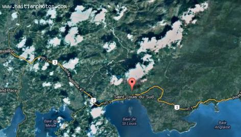
Map of Saint-Louis du Sud
Here is a map of Saint-Louis du Sud provided by google satellite. Located in the South Department of Haiti, its geographical coordinates are 18° 16' 0" North, 73° 33' 0" West. There are several forts in the area
Founded in 1698, the city takes its name from Saint-Louis-du-Sud in 1721. Fort Olivier is located on the west side and is easily accessible. Another fort is Fort des Anglais and the only way to access this one is by boat. Out on Fort des Anglais, you can still see the rusting cannons that the British would use during their fightsfrom 1611 to 1753.
Read more about haiti map, map, Fort, Saint-Louis-du-Sud, Haiti

 A $800,000 Home occupied by Deputy Rony Celestin confiscated
  Duty Free Americas (DFA) store at Toussaint Louverture...
  Haiti License Plate or Plaque d'immatricules a DGI
  Jean Henry Céant deposited documents in Parliament for...
  Rafael L. Trujillo welcoming Paul Magloire in Santo Domingo
  Meet Haitian-American professional baseball pitcher Touki...
  Delimart Plaza, Delmas 32, Port-au-Prince, Haiti being looted
  Haitiano-Japanese Naomi Osaka wins the US Open against Serena...


